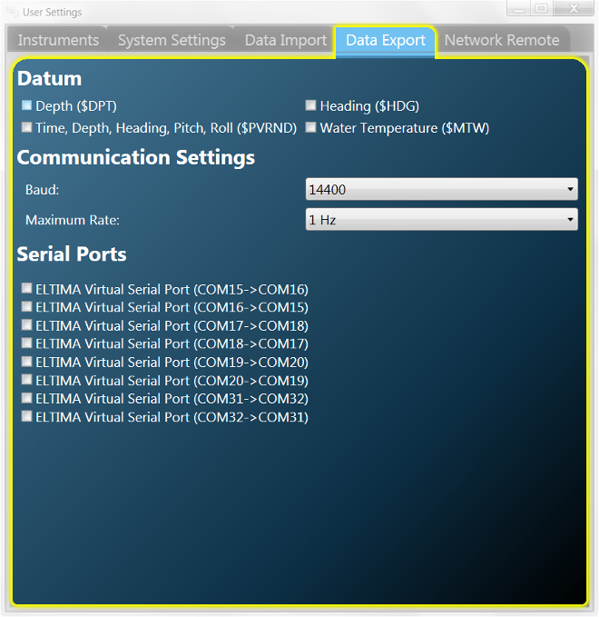
Data Export
Data Export can be used to send VideoRay Cockpit and ROV data to other applications.
 Improperly setting up COM ports for Export can cause problems with basic ROV communications. If you are not sure how to set up COM ports, contact VideoRay support for assistance. Improperly setting up COM ports for Export can cause problems with basic ROV communications. If you are not sure how to set up COM ports, contact VideoRay support for assistance.
 The Serial Ports list may be different based on the computer's configuration. The Serial Ports list may be different based on the computer's configuration.
Data Export sends data as NMEA* formatted text strings and supports four different types of output strings:
- Depth ($DPT)
- Heading ($HDG)
- Water Temperature ($MTW)
- Time, Depth, Heading, Pitch, Roll ($PVRND)
Data Export sends data to a COM port. Either a physical COM port or virtual COM port can be used. Virtual COM ports can be used to allow two programs on the same machine to talk to each other. An example might be to have VideoRay Cockpit send the ROV Depth to a program that could log and/or graph the depth profile of the mission. See the Application Integration section for more information about virtual COM ports.
To use Data Export, you must configure the data type, Baud rate and frequency of output (Maximum Rate) and then select the port to which you want to export data.
 To save data to a file, you can use a terminal emulation program, such as or Tera Term or PuTTY, as the receiving application and save the session data to a log file. To save data to a file, you can use a terminal emulation program, such as or Tera Term or PuTTY, as the receiving application and save the session data to a log file.
Data Export Format
The prototypical format conforms to NMEA standards and can be expressed in general terms as:
$IDSEN,DD,DD,...*CS<CR><LF>
| Segment | Information Represented |
|---|
| $ | Start |
| ID | Talker Identifier, which is "VR" |
| SEN | Sentence Type, which defines the type of data in the string |
| DD,DD,... | Data field(s), fields are separated by commas |
| * | Separator |
| CS | Checksum |
| <CR> | Carriage Return |
| <LF> | Line Feed |
Example Output
Depth - $VRDPT,d.d,o.o*cs
| Segment | Information Represented |
|---|
| $VRDPT | Depth Record Identifier String |
| d.d | Depth in meters |
| o.o | Transducer offset (set to zero)
Positive means distance from transducer to water line
Negative means distance from transducer to keel |
| cs | Checksum |
Heading - $VRHDG,h.h,d.d,a,v.v,b*cs
| Segment | Information Represented |
|---|
| $VRHDG | Heading Record Identifier String |
| h.h | Magnetic sensor heading in degrees |
| d.d | Magnetic deviation in degrees |
| a | Magnetic deviation direction, E = Easterly, W = Westerly |
| v.v | Magnetic variation in degrees |
| b | Magnetic variation direction, E = Easterly, W = Westerly |
| cs | Checksum |
Water Temperature - $VRMTW,x.x,u*cs
| Segment | Information Represented |
|---|
| $VRMTW | Water Temperature Record Identifier String |
| x.x | Degrees |
| u | Unit of measurement |
| cs | Checksum |
ROV Attitude - $PVRND,mm/dd/yyyy,hh:mm:ss.s,d.d,h.h,p.p.r.r*cs
| Segment | Information Represented |
|---|
| $PVRND | ROV Attitude Record Identifier String |
| mm/dd/yyyy | Month/Day/Year |
| hh:mm:ss.s | Hours:Minutes:Seconds (UTC) |
| d.d | Depth in meters |
| h.h | Magnetic sensor heading in degrees |
| p.p | Pitch in degrees |
| r.r | Roll in degrees |
| cs | Checksum |
You can select more than one output string. Each string will be written in sequence.
You can select more than one COM port and export to several applications simultaneously.
* - For more information about NMEA and NMEA data standards, see http://www.nmea.org or http://www.tronico.fi/OH6NT/docs/NMEA0183.pdf.
|